Sort file:- Canterbury, June, 2026. |
||||||
Page Updated:- Wednesday, 24 June, 2026. |
||||||
| PUB LIST | PUBLIC HOUSES | Paul Skelton | ||||
|
Earliest 1630s- |
Queen's Arms |
Latest 1741- (Name to) |
||||
|
Stour Street St. Mildred's Canterbury
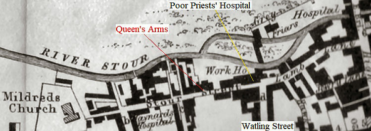
This one appears to be a different one from the "Queen's Arms" located in the Northgate area of Canterbury. Rory Kehoe goes on to give the following information:- "The pub's exact location isn't yet known but it was possibly on the north side of Stour Street, maybe on/near the site of what later became the "Two Brewers." This "Queen's Arms" appears to have traded from the 1630s until the first half of the 18th century, in what was then part of the semi-rural western outskirts of Canterbury. This area was developed in the 18th century into what we now know as Stour Street, this being an extension of Lamb Lane, which ran from the High Street to the corner of Beer Cart Lane. The "Queen's Arms" was certainly within the parish of St. Margaret and was described as being "near Watling Street" and referenced (Woodruff) in an estate document:- "land belonging the to the Hospital for Poor Priests, next to the "Queen's Arms."" The above map circa 1800 indicates the approximate location of the "Queen's Arms, based on current information.
LICENSEE LIST JOHNSON Bart 1649+
|
||||||
|
If anyone should have any further information, or indeed any pictures or photographs of the above licensed premises, please email:-
|
||||||
| TOP |
|
|
||||