Page Updated:- Wednesday, 24 June, 2026. |
|||||
 Published in the South Kent Gazette, 6 August, 1980. A PERAMBULATION OF THE TOWN, PORT AND FORTRESS. PART 102.
COWGATE HILL Many changes have taken place in this district. Much of it was due to change under clearance and replanning schemes and then enemy action played its part during ‘the Hitler war. Cowgate Hill is a short street with the Cowgate Almshouses on the south side, and a row of houses on the north. The almshouses were founded by the late Mrs Susan Gorely, and erected in the year 1877 for 20 aged persons, each of whom received 3/6 per week. The top house on the opposite side of the street was for a good many years the residence of Mr John Gilbert, Seaman’s Missionary at Dover, who died there in May 1890. Mr Gilbert acted for more than forty years as Seaman’s Missionary at the port of Dover, and for 37 years was the Dover agent of the British and Foreign Sailors’ Society. During that 37 years he visited 316,865 vessels, held 5,411 Bethel meetings, at which there attended 868.310 sailors and others. He distributed, either giving or selling, 18,180 copies of the Bible, gave away 9,243 copies of the Gospels, distributed 585,103 religious tracts and magazines, and 2,167 French and Italian religious books; and he induced 6,000 persons to sign the temperance pledge.
DURHAM HILL Parallel with Cowgate Hill northward is Durham Hill. On the south side at one time it was bounded by the Prospect House School playground, and the ends of Portland Place and Hartley Street, and on the north by the Dover School of Industry, established by the ladies of Dover in the year 1818 to educate and train sixty girls. The school was commenced in Queen Street, and this building was erected in 1827, when the ladies of Dover generally lent their aid to the work. Owing to the nation taking elementary education in hand, this school ceased to exist long ago, Until 1914 the building was used for religious meetings. Above the School of Industry up to the top of Mount Pleasant, the northern side of the hill was devoted to cottages built at various dates from 1830 to 1850, some of which survive.
BOWLING GREEN LANE This steep road, parallel with Cowgate and Durham Hills led from York Street, past Union Row and Blucher Street on the right and Durham Place on the left, up to Mount Pleasant. This road obtained its name from the circumstance that, about 140 years ago, on an excavated plateau under the Western Heights, there was an enclosed bowling green, which was then a favourite resort of the military officers and gentlemen of Dover The bowling green has long ceased to exist, and the buildings within the enclosure were converted into a common lodging house. The name Mount Pleasant is a reminder of the time when the associations of this commanding elevation were a great deal more pleasant than they became later and when Bowling Green Lane was an approach to a real bowling green. At Mount Pleasant there were later built rows of cottages across the top of the hill, facing the enclosed area which was once the bowling green.
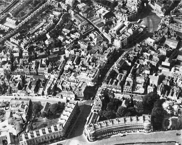
An aerial view of an area which has seen a tremendous number of changes since this photograph was taken in the early 1930s. Running diagonally across the picture to the Market Square (top right), are New Bridge, Bench Street and King Street. In the foreground are Cambridge Terrace and Camden Crescent and, on the extreme right, the curious building, earlier referred to, known as Shipdem’s House which was a victim of enemy action in the Second World War. The majority of the property behind Camden Crescent and Shipdem’s House was cleared after the war due to bomb damage or because of redevelopment. Behind Cambridge Terrace is Northampton Street, all of which has been swept away due to bomb damage or the construction of the Townwall Street dual carriageway and roundabout, along with much of New Bridge and some of Snargate Street. But the greatest change has taken place between Snargate Street and Queen Street, along the route of the York Street dual carriageway. Here most of the property, schools, houses, almshouses and many business premises, have been demolished since the last war.
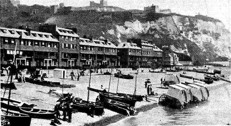
The picture, above, is a reminder of the days when Dover laid claim to being one of the south-east’s seaside resorts. It dates from the 1920s.
|
|||||
|
If anyone should have any a better picture than any on this page, or think I should add one they have, please email me at the following address:-
|
|||||
| LAST PAGE |
|
MENU PAGE |
|
NEXT PAGE | |