Page Updated:- Sunday, 07 March, 2021. |
|||||
 Published in the South Kent Gazette, 4 March, 1981. A PERAMBULATION OF THE TOWN, PORT AND FORTRESS. PART 161.
DISTINGUISHED NAMES In 1885 the roads on the north side were laid out, and Mr. Edward Knocker, then Town Clerk, selected for them the historic names of Ethelbert Road, Odo Road, Widred Road and Edred Road; and, at the same time, by his suggestion, the old name of Black Horse Lane, reminiscent of public executions, was changed to Tower Hamlets Road. The new roads with the Saxon names were laid out by the Freehold Land Society. In due course they were lined with houses, and all became public thoroughfares except Edred Road, which was not made up for many years. The last-built section of the lower area of Tower Hamlets was Dickson Road, about 1880 (between Tower Street and Tower Hamlets Street), containing forty dwellings, and named after Major Alexander G. Dickson, who was Member of Parliament for Dover from 1865 until 1889. The extension of Tower Hamlets, west of South Road, began in 1896 with Wyndham Road, containing about 80 houses, named after a former Member of Parliament for Dover, the Right Hon. George Wyndham, who succeeded Major Dickson; Douglas Road and Lowther Road, with about 90 homes, named after a Member of Parliament for St. Augustine’s and a Member for Thanet, run parallel with each other; and Noah’s Ark Road, with 35 houses, named after the old dairy farm at its western end. Further advanced still is Devonshire Road, containing 45 houses, making a total of 254 houses built there up to 1906. Later developments were Anselm Road, named after an early Archbishop of Canterbury, Hamilton Road, believed to have been named after the Duke of Hamilton, and Chamberlain Road, named after politician Joseph Chamberlain. They run parallel to one another oft Northbourne Avenue, which was named after Lord Northbourne. About a quarter of a mile of open space, entirely taken up by the sports fields of the Boys’ Grammar School and Astor Secondary School, separate Tower Hamlets and homes in the Elms Vale area.
FEVER HOSPITAL On the north side of Tower Hamlets, the summit of Chapel Mount is occupied by the old Dover Corporation’s former Fever Hospital, better known in recent times as the Isolation Hospital and no longer under council control. This was well isolated from surrounding homes. It was originally established, on a small scale, by Dr. Astley about the year 1871, and was of great use in the smallpox epidemic of 1872. Demands for further accommodation led to several enlargements and eventually the doctor, on very liberal terms, handed over the whole establishment to the Corporation, as the Urban Sanitary Authority, which, by further enlargements, made ample accommodation for isolation of all cases from the Dover Urban and Rural Districts, with the exception of smallpox and cholera; and for such cases, should they occur, a special hospital was provided, about a mile and a half away, in a lonely part of the Poulton Valley.
LONDON ROAD MEMORIES London Road, commencing at the top of High Street, is a highway that, before the days of railways, resounded with the horns and the rattle of the London coaches. Here, until 1855, stood the gate where tolls were collected for the Turnpike Trust. This part of the London Road was not in use in ancient times, when monarchs made their progresses to Dover, and armies marched down to the coast in the impressive panoply of war; but in later days it has witnessed some such scenes. In April 1813, down the road came the King of France, attended by the flower of the English nobility, and an enormous crowd of humbler persons, who, some mounted, and many more on foot, had marched forty miles or more to see the long exiled monarch embark for his dominions. Up the same road in June 1814, came the Emperor of Russia, the King of Prussia, and a vast train of great warriors, who were on their way to London, to celebrate the vanquishing and banishment of Napoleon; but, In less than a year, down this same road marched regiment after regiment of brave English youths, hurriedly gathered from the Militia of the forty counties, to have their final tussle with the disturber of Europe on the Field of Waterloo. It is believed that the progress of Charles II at his Restoration, the great cavalcade that came with Charles I, in 1625, to meet Queen Henrietta, and other similar processions, took another route. Anciently the London Road east of the river, leaving the present road on Crabble Hill, entered the town near the old harbour under the castle. After the establishment of the Maison Dieu, the main road passed through Biggin Gate, and up High Street, crossing the river ford to the old road at Charlton Green; and the present London Road from High Street to Crabble Hill, is supposed to have been made about two hundred years ago.
LEPER HOSPITAL St Bartholomew’s Hospital for Lepers existed, previous to the Reformation, on the side of Chapel Mount; its chapel and grounds are supposed to have extended from the green hillside to the river. Not a fragment of the hospital remains, for, after the suppression, there was not left one stone upon another. It is impossible, therefore, to point to the exact site, either of the hospital or the chapel, but the chapel is supposed to have been on the green mount above .the old Wesleyan chapel, and other buildings occupied the ground above and below the boundary between Charlton and Buckland. The rules and constitution of the House are preserved in a manuscript at the Bodleian Library, Oxford. The hospital was established in the year 1152 by the brothers Osborne and Godwin, of St Martin’s Priory, with the consent of the Prior, who gave a piece of land, called Thega, between the foot of the hill and the river, for its use; and like numerous Other hospitals for lepers which existed at that period, it was dedicated to St Bartholomew.

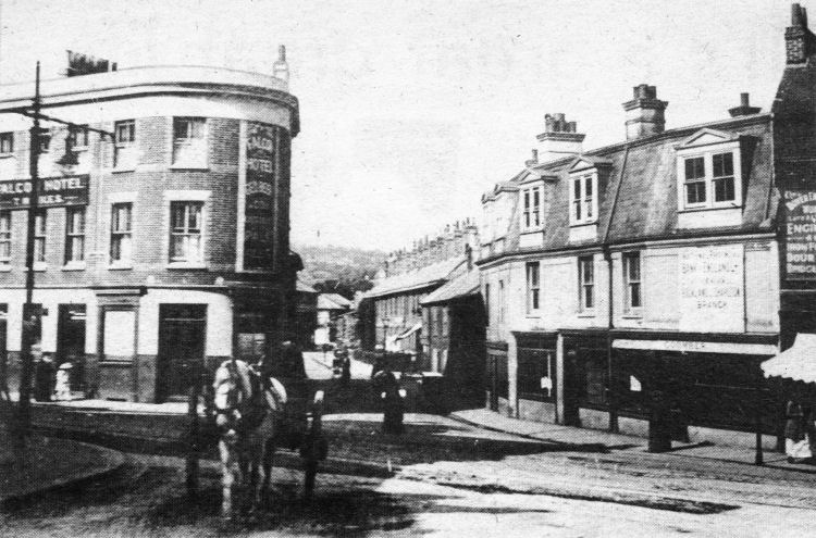
Once the site of a tollgate and a gatehouse this is the London Road-Bridge Street junction with High Street and Tower Hamlets Road, as it appeared about 80 years ago. On the left at the corner of Bridge Street is the old Falcon Hotel while, on the right, on the High Street corner is Coomber’s fruit shop. On the fascia of this is a sign announcing that the site had been acquired for the construction of the Buckland and Charlton branch of the National Provincial Bank — now the National Westminster Bank. The sign gives the clue to the date of the picture because the bank opened for business about 1901. Another sign, on the extreme right of file picture, is an advertisement for the Dover Engineering Works Company (previously Thomas and Sons) — “Engineers and Iron Founders, Dour Works, Bridge Street.“ In Bridge Street itself is a line of terraced homes all of which have now disappeared, the site having been taken over by the foundry. 
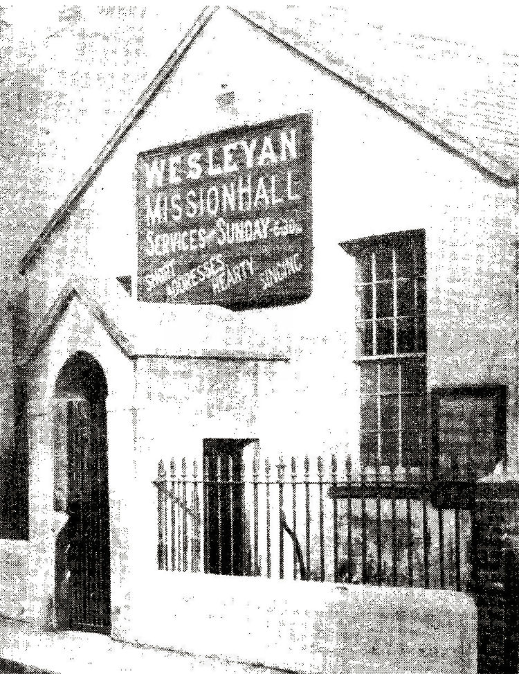
The picture, above, is of the old Wesleyan mission hall in Tower Hamlets.
|
|||||
|
If anyone should have any a better picture than any on this page, or think I should add one they have, please email me at the following address:-
|
|||||
| LAST PAGE |
|
MENU PAGE |
|
NEXT PAGE | |