Page Updated:- Wednesday, 24 June, 2026. |
|||||
 Published in the Dover Express, 3 April, 1981. A PERAMBULATION OF THE TOWN, PORT AND FORTRESS. PART 170.
DESTROYED BY SHELLING According to Miss Rookwood, Arthur had his revenge. He practised with a shotgun until he could hit the large bell that the Fieldings used to summon their servant, and Potts would drop whatever he was doing and go into the house to see what the family wanted. It is reputed that poor Potts never did find out who sent him on false errands back into the house! There was also trouble when Arthur’s father smoked his pipe in his garden. Potts would be sent with a message to ask Mr Thomas to stop polluting the atmosphere! Eventually young Arthur realised his childhood ambition to own Bucklands, in 1919. He lived there for a number of years and eventually sold the property to the Gas Board. During the Second World War customs officials commandeered the house, which had 16 rooms and wails 24 inches thick, and were still using it when it was destroyed by shelling in 1942. The site of the workshop of the Thomas family from which, presumably, young Arthur had a good view of the Fielding’s garden and the bell, was later occupied by an Apostolic Church.
Chapter XV
OLD BUCKLAND Buckland Bridge is the centre of old Buckland with its ancient church of St Andrew, the famous yew tree in the churchyard and the ancient mill lands. South-east lies Barton, a comparatively modem residential district with an old manorial root and north Is the even more modern Buckland Estate which probably contains the largest group of council houses in the town. Buckland Bridge is a convenient point from which to make a survey of the central part of Buckland. The bridge itself is not an ancient landmark, but its origin extends well beyond living memory. The historian Hasted, writing near the close of the 19th century, speaks of the river Dour here, “over which there is a newly-built brick bridge.“
BRIDGE RENDEZVOUS This bridge, from its earliest days, was a favourite place to meet and welcome distinguished strangers, and, before the time of railways, politicians used to meet their Members of Parliament or candidates at this spot, welcoming them with brass bands and silken banners. Many such instances might be mentioned, but it will suffice to quote from the papers of the period, the public entry of the Hon. John Halcomb, a man much beloved, although sometimes rejected by the freemen of Dover. On the 27th of May, 1826, he and his friends passed over Buckland Bridge in the following order: (1) Halcomb's standard, scarlet and blue, surmounted by a large gilt fighting cock; (2) three scarlet and blue banners; (3) a band of music; (4) freemen marching four abreast; (5) drum and fife band; (6) sixteen banners; (7) vanguard, consisting of part of his committee, mounted, two abreast; (8) Mr Halcomb in his open carriage, drawn by the people; (9) rearguard, consisting of part of the committee, mounted, two abreast; (10) freemen, marching four abreast. That was but a sample of many other political processions which passed over the bridge in the days when bands and banner were in accordance with law. And there must have been here many other notable scenes, the most memorable of which is said to have been the meeting, on this bridge, of those two great warriors, Wellington and Blucher, on the 11th of July, 1814.
ANCIENT BOCKELAND The history of Buckland requires a glance much further back than the days of Buckland Bridge. The name of the place, anciently written Bockeland, according to Hasted, carries us back to Saxon times, for he says; “Bockeland took its name from two Saxon words, boc, or book, and land, meaning that it was land held by charter or writing.“ That was before the Conquest, for after that event part of the land in this parish was vested, by the will of the Conqueror, in Odo, Bishop of Bayeux, who had an under tenant, as recorded in Domesday Book thus: “Ansfried holds of the Bishop in Bockeland half a suling, and he has in demesne one carucate and one villein. In the time of Edward the Confessor it was worth 20 shillings. When Ansfrid received it, it was 30 shillings, and now 40 shillings.“ This half-suling holding, consisting of 108 acres of our present land measurement, represented the manor of Buckland, as distinct from those of Barton and Coombe, which, before the Conquest, were held by the Canons of St Martin, which property the Normans respected. The tenant Ansfrid seems to have been called upon to pay rent, which was eventually double that which was paid in Edward the Confessor's time, and that for a very lean holding, which was economically worked by one plough and one bond servant.
OWNERS AFTER ODO In 1082, after a short possession of 16 years, Odo was deprived of his great possessions, when the manor of Buckland was given to Hamo de Crevequer, surnamed Vicecomes, for knight's service in the Castle guard; but it is not probable that that great Norman ever resided at Buckland, for he was a man of many possessions, more particularly in the neighbourhood of Maidstone, he being, for the remainder of his life, High Sheriff of Kent. The Crevequer family held on to Buckland and their other possessions until they became involved in the Baronial wars. In the reign of Edward II, the last of them, who defended Tonbridge Castle against the King, was hung in the year 1317. Buckland manor passed to the Barries, of Sevington, a Norman family, who intermarried with the Saxon Sevingtons of Sevington. Their holding of the Buckland manor was practically freehold, their acknowledgment to the King being the payment of one red rose annually.
BUCKLAND FARMHOUSE The Court of Buckland manor which, with Buckland Farm, spanned over 100 acres, was the old Buckland farmhouse, which stood on the sate of the Hollis Motors Garage and was taken down by Major Murray Lawes in 1897. There were deposited in the Dover Museum some tiles from the chimney-piece of this old house, and portions of its masonry, which indicate that it was of ancient date.
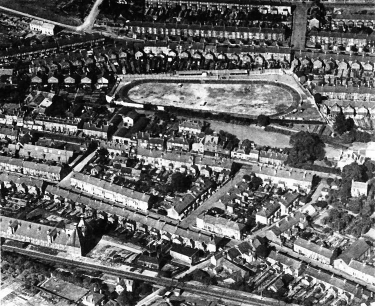
An aerial view of the Auckland area in the early 1930s. The most prominent feature of the picture is the old greyhound racing track between Buckland Avenue, near the top of the picture and the millpond of Mannering’s Mill just right of centre- A glimpse of the mill, painted white, can be seen on the right side of the picture. The track finally disappeared in the mid ’30s when Alfred Road was extended across it. The track had been laid oat, in part, on the site of the old Willow Walk which ran into what used to be known as Brock Ditch Meadow alongside the River Dour. Houses in Lorne Road and Alfred! Road now stand on the meadow land. Part of the old Willow Walk survives in the form of a little lane behind houses on the north side of Alfred Road. London Road runs across the middle of the picture, the roads leading off it, from right to left being St Radiguiid’s Road, Eric Road and the cul de sac adjoining the old Buckland School. The main Dover to Canterbury railway line runs across the bottom of the picture, the large building alongside it, on the right, being a malt-house once in the ownership of Leney’s the brewers. Other roads in the foreground, running parallel with London Road are Oswald Road and Magdala Road.
|
|||||
|
If anyone should have any a better picture than any on this page, or think I should add one they have, please email me at the following address:-
|
|||||
| LAST PAGE |
|
MENU PAGE |
|
NEXT PAGE | |