Page Updated:- Wednesday, 24 June, 2026. |
|||||
 Published in the Dover Express, 19 June, 1981. A PERAMBULATION OF THE TOWN, PORT AND FORTRESS. PART 192.
LONDON ROAD The London Road, which used to be known as Upper Road, from Kearsney Station to Crabble Hill, has been developed as a suburban part of Dover, and since the 1904 extension of Borough boundaries has been within the town boundary. Before this extension however, there was already an almost continuous line of detached houses and bungalows with picturesque surroundings, and a pleasant view over the River vale, stretching from the top of Crabble Hill to Kearsney. Half way between Buckland and Kearsney were the engineering works and yard of Messrs Robson, one of the local traction engine proprietors and agricultural engineers, which was for many years an important Crabble Hill industry. The disappearance of those works and the utilisation of the ground for the construction of modern small houses, reflects a change in methods of transport and agriculture. Traction engines, with their trains of wagons would be a strange sight on the roads today. Tractors have taken their place on farms where a pair of traction engines used to stand, one on either side of a field, and haul a plough across from one side to the other by means of a cable or rope. On the northern side of the Upper Road, at Kearsney, is the Railway Hotel, adjoining which is Kearsney Avenue, extending up the Whitfield Valley and connecting up with Whitfield Hill. The garage business at the corner of London Road and Kearsney Avenue was formerly the site of the Kearsney Temperance Hotel. The numerous large houses in the vicinity, such as Woodside, now a boys’ home, were built for prominent local businessmen. In the case of Woodside this used to be the home of Sir William Crundall who, apart from his business interests was also thirteen times mayor of Dover, and a local and county magistrate. His public service and efforts to bring about the modern development and enlargement of Dover harbour, together with town improvements, was marked by the hanging in the town hall of a large portrait.
WELLINGTON’S ARMY Prom Woodside to the top of Crabble Hill there are no houses on the north' side of London Road because the ground slopes steeply up to Old Perk, now the site of the barracks and quarters of the Royal Engineers’ Junior Leaders’ Regiment. The hillside in the old days was an open down upon which, according to tradition, the large numbers of troops which marched down to the coast to reinforce Wellington’s army before the Battle of Waterloo, bivouacked while waiting for ships to transport them across the Channel. When the Barham Turnpike Trust was formed, the sharp cop on the brow of Crabble Hill was excavated to make the gradient easier, and the high bank left on the Old Park side was planted with fir trees.
BUCKLAND ESTATE Leading off the northern side of London Road is Pilgrims' Way which gives access to the first of the municipal housing enterprises built in 1925, and known as Buckland Estate. The services of Professor Abercrombie were engaged for the layout of these homes. The houses were erected under the 1924 Housing Act by which the town had to contribute a penny rate towards the annual payments for the Interest and sinking fund. Built when home prices were still high, following the First World War, they met an important need. Chaucerian names were chosen for the first of the estate roads, such as Shipman’s Way, Pardoner’s Way and Knight’s Way, but there is no historical association of the spot with the Canterbury Tales, although pilgrims from the Continent may have passed that way.
Chapter XVII
TRANSPORTATION When Queen Elizabeth I made her spectacular tour of Kent in 1573, she came to Dover not via London Road but by way of Capel, the Western Heights and Cowgate into Queen Street which must have been quite a trek. Lord Burleigh, who was a member of that glittering cavalcade, has left it on record that the route was as rough and dangerous as any in the Peak district of Derbyshire. Six horses were needed for each of the thousand or more two-wheeled waggons which, with a thousand people on horseback, made up this remarkable royal entourage, the last of which is said to have been toiling up Folkestone Hill when the leaders were riding down Queen Street into Dover. Those two-wheeled waggons were examples of the lumbering type of carriage in which important people began to travel about in Queen Elizabeth’s time. Stage coaches were still some way off. They didn’t make their appearance on the Dover road until the 18th century and it was then that the road system began to become quite inadequate. In places the roads, no more than tracks, would be so deep in mud that even four horses could not pull a coach at much more than walking pace and a journey to the capital normally took two full days.
DOVER COACHES The Royal Oak, in Cannon Street, was the main coaching station in Dover and the London stage coaches left there every day at 4 o’clock in the morning and 6 o’clock in the evening. Mail coaches, as distinct from the stages, began to run regularly between Dover and London in 1736, their point of departure being the old York Hotel at the seaward end of Union Street. They set out every morning at 7 o’clock, bound for the George and Blue Boar, in Holborn. The earliest recorded regular road service to London for merchandise was Rutley’s old Dover Waggon, which left Snargate Street every Monday and returned from London on Saturday. Others had joined this service by the end of the 18th century, one advertisement of the 1790s intimating that luggage cost six shillings (30p) a hundredweight on Marie’s waggon, which left the Royal Oak every Wednesday at noon. Communication with London improved when coaches from Dover were able to link up with a steamer service to and from the City operated to Herne Bay Pier.
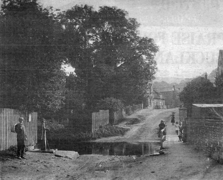
Believed to date back about 80 years this is a view of the old foord at Common Lane, River. It was taken from a position close to the junction with Lower Road and the old River Co-operative Society store. The foord is believed to have given rise to the name Weeford House for the property which is off the picture to the left. One wonders what the wording was on the old notice board behind it — a warning that the water might not be fit for drinking perhaps? On the right children are playing on the pedestrian footbridge over the river. Beyond, on the right is what is now the village hall. Near the centre of the picture is a property known as Beresford House where Mr A. Tritton had a bakery and post office business. Further on was a general shop owned by S. Goldsmith and near what is now Lewisham Road, the tea gardens of W. W. Wells.
|
|||||
|
If anyone should have any a better picture than any on this page, or think I should add one they have, please email me at the following address:-
|
|||||
| LAST PAGE |
|
MENU PAGE |
|
NEXT PAGE | |