Page Updated:- Sunday, 07 March, 2021. |
|||||
 Published in the South Kent Gazette, 22 August, 1979. A PERAMBULATION OF THE TOWN, PORT AND FORTRESS. PART 21.
THOMAS DAWKES. One of the plots of void land was let on a 99 years’ term to Thomas Dawkes, yeoman, on which probably he built the “Flying Horse Inn“, which was a well known house on the east side of King Street at the time of the Commonwealth, supposed to have been then held by the Richard Dawkes who, during the Civil War, successfully conspired with others to seize Dover Castle for the Parliament. The 99 years for which this void land had been let, at the nominal ground rent of one shilling a year, together with the obligation of service to the Sovereign, had drawn near to the end of its term when Richard Dawkes and his companions seized the castle, but the restoration following soon after, it may be presumed that owing to the direct violation of the “service“ clause of the lease, Richard Dawkes and the “Flying Horse“ parted company. The plot to seize the castle has always been said to have been hatched at the “Flying Horse,“ which was originally called the “Fleur de Lis.“ That was its name in the reign of Elizabeth, and the title deeds, bearing date 1600, described it as the “Flower de Luce.“ The name was afterwards changed to the “Flying Horse,“ to suit its character as a posting house. Thomas Dawkes, the yeoman, who leased this land and built the house, had made himself a considerable position in Dover. He was one of the two Commissioners appointed by deed to collect the subsidy, or benevolence, that Queen Mary granted for the Harbour; he was at one time the holder of the land attached to St. Martin’s Church; later he is described as the Common Clerk.
RICHARD DAWKES SEIZES CASTLE. Richard Dawkes, who was probably grandson of Thomas, had a wild and daring spirit. The association with men on the road had probably infected him. Taking with him 10 other men as daring as himself, they, in August, 1642, formed a plan to seize the castle for the Parliament. On the night of the 20th of August in that year, the 11 met at the “Flying Horse,“ and, departing separately, they are said to have met at the castle cliff, and scaled the face of it; but it is more probable they climbed the slope near the sea from the Northfall Meadow, where, owing to the neglected state of the works, they were easily able to effect an entrance. At any rate, the 11 men gained the elevation in front of the Pharos, and, climbing the wall which surrounded the Saxon outworks, surprised the guard, who, in the darkness, thinking their assailants more numerous than they were, surrendered without resistance. A thrilling narrative of this affair has been written, adorned by circumstantial details and local colour; but it was not a very great exploit, for the guard only numbered four men, and the residue of the soldiers in the castle were but 16, making 20 all told. When it was too late, the Royalists sent a force of 2,000 Kentish men, under Sir Richard Hardres, to re-take the castle; but Sir Algernon Sydney and General Fairfax were there first, and the virgin fortress, seized by the handful of King Street conspirators, remained in the hands of Parliament until it was surrendered to Charles II on his Restoration. Looking on the frontages on the east side of King Street today, we see much variety, but nothing that appears to have existed from the days of Queen Elizabeth. The interiors, however, of several of the houses are antiquated. One of the old properties — Regent House —was, in the early part of the last century, the residence of Mr. William Cocke, surgeon, a highly popular man in Dover, who was eight times Mayor. All the houses on this eastern side of the street were built on a low level, not much above the tidal height of the river.
THE WIDENING. The widening of King Street was effected by an Act of Parliament passed in 1826, and the schedule of property taken down included the “Fountain“ alehouse, at the Market Place corner, then the property of Messrs. Flint and Co. It was rebuilt, set back to the new building line. Sold late in 1912 it was demolished in 1915 to provide a site for the enlarged bank premises of the Westminster Bank—formerly the London and County Bank—now the Nationwide Building Society offices. The next house to the corner, No. 2 (for the numbering today is reversed), was also the property of Messrs. Flint and Co.; No. 3, the residence of Mr. G. W. Ledger, owned by Mr. John Shipdem; No. 4, a loft owned by George Dell (an ancient building supposed to have been the original Guildhall); No. 5, a house that had been the residence of Dr. King No. 6, a house belonging to Mr. Kingsford; No. 7, a house belonging to Mr. George Reeves; No. 8, a baker’s shop, part owned and occupied by Thomas Loud; No. 9 and No. 10, owned by Mr. John Corbett (No. 10 later was the pharmacy of Mr. E. Thompson, and was eventually re-built to form the premises for the Capital and Counties Bank, later amalgamated with Lloyds Bank). Housed at the back of No. 9 (until 1927 the Dover Chronicle office), in Gaol Lane, was the printing office of James Cleveland. All these, with other property in Goal Lane and Queen Street, were removed. Before that time the roadway was but 15 feet wide, and the footpath hardly wide enough for a single person. Yet this cramped road was a very important route of traffic. The end of it next Bench Street was at that time called Ford’s Corner, and by a sharp turn into Butchery Lane (as Fishmonger’s Lane was then called), the road led across St. James’s parish to the Eastern Harbour. The other end of this narrow street made a sharp turn into the Market Place.

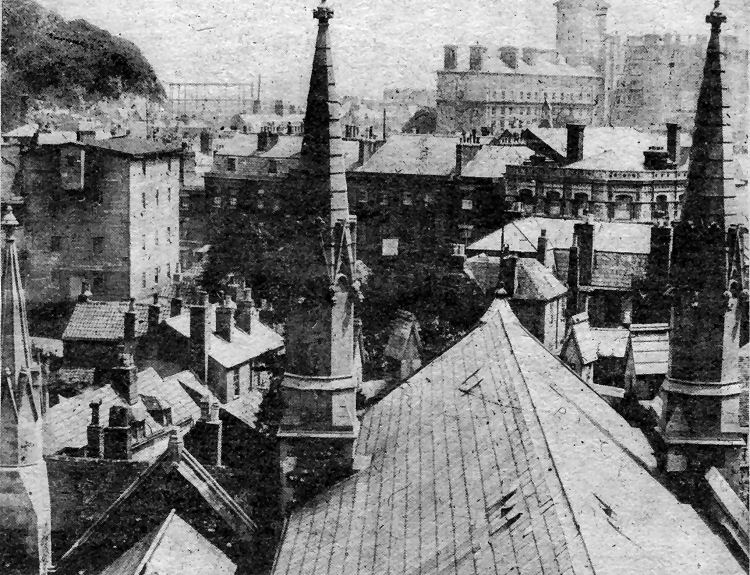
A unique view of old Dover from the roof of St. Mary’s Church with
Stembrook Mill left, the old gas works site near the seafront on the
skyline, Castle Street running across the centre and the great bulk of
"Burlington Hotel" which stood near what is now the junction of Townwall
Street and Woolcomber Street, on the right. 
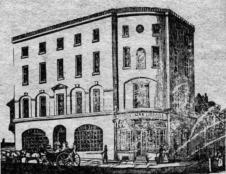
A woodblock engraving over a century old of Batcheller’s Library, later the "Hotel de France" — now demolished — which stood at the corner of New Bridge and Snargate Street.
|
|||||
|
If anyone should have any a better picture than any on this page, or think I should add one they have, please email me at the following address:-
|
|||||
| LAST PAGE |
|
MENU PAGE |
|
NEXT PAGE | |