Page Updated:- Wednesday, 24 June, 2026. |
|||||
 Published in the Dover Express, 10 October, 1980. A PERAMBULATION OF THE TOWN, PORT AND FORTRESS. PART 121.
RIPARIAN IMPROVEMENT In the formation of Maison Dieu Road, its one drawback was the fact that the level of its surface in some parts was but 2ft. above the ordinary level of the River Dour. This did not so much affect the sewerage, which was at an early date connected with the main arterial sewer passing down Biggin Street but there was much trouble in disposing of the surface water. It was proposed, when finally making up the road in 1863. to raise the surface 3ft. opposite Brook House grounds, but it was not done. As a result of not carrying out that idea, there was from time to time, trouble from flooding; but a remedy was effected by the Dover Corporation, about 75 years ago by purchasing the riparian rights at Stem-brook Mill. The level of the river was then permanently reduced about 2ft., which not only obviated the flooding, but greatly enhanced the sanitary condition of the whole of the lower half of Maison Dieu Road.
PENCESTER ROAD There was no cross road from the main thoroughfare to Maison Dieu Road, between Castle Street and Bridge Street, until the year 1860;. nor was there any great need for one, because the whole area eastward was agricultural land. In the year 1854 the Gunman estate, which had descended to a member of the family named Jarvis, came onto the market, and Pencester Road was laid out by Mr William Moxon. The vendor made an allowance for the cost of building a bridge over the river, and the conveyances provided that the builders of houses should, if they desired, have the option of keeping the thoroughfare private. Soon after the erection of houses was commenced, and before the surface of the road was metalled, Mr Moxon’s financial difficulties brought matters to a standstill, the river only being bridged with a plank. The bridge was built in 1863, and at that time the road was neither kerbed nor channelled.
ABSENCE OF BYE-LAWS The by-laws regulating the laying out of new streets had not been adopted when this road was commenced; and when, at a later date, the owners were called upon to complete the road according to the by-laws, which had in the meantime been brought into force, the proprietors objected to acknowledge the ex post facto regulations. By that time the houses in the Maison Dieu Road had been built, St James’ New Church had been opened, and Pencester Road was a convenient route from the Castle to the Priory Station. Under those circumstances, the Town Clerk, the late Mr Edward Knocker, overcame the difficulty by advising that, for the public convenience, it was within the power of the council to finish the road at the public expense. On that advice the road was taken over in August, 1863, and completed at the public charge.
GUNMAN’S LANDS The semi-detached villas which soon lined this road from end to end, except a space left on the south-west of the river, were then regarded as pleasant places of suburban residence, occupying the grounds which had been attached to Gunman’s mansion; and it stall continues to be the nearest residential soot to the centre of the town. The Biggin Street end of the road was built upon, in 1860, by Messrs Barker an the south (which was later Murdoch’s music shop for many years) and by Messrs Coulthard and Wilson on the north, the old comer premises of the latter, which later became the site of the Midland Bank, being on the site of Gunman’s Mansion.
PENCESTER MEADOW The public recreation ground once known as Pencester Meadow and now known as Pencester Gardens, on the south side of Pencester Road, has attached to it a little history. When the street was laid out in 1860, it was intended to devote the site to a smaller class of house property, a street, to be called Neville Road, being laid out from the corner of the second pair of villas from Biggin Street, the idea being to carry it in crescent shape towards Dieu Stone Lane, with an outlet over the river to Eastbrook Place. The project did not find acceptance with builders. The late Mr William Crundall was then the owner of it, and about the year 1880 the field passed into the hands of Sir Edward Watkin, who acquired it with the intention of using it for a Dover station in connection with the Channel tunnel, which it was then proposed to make from St Margaret’s. That project also failed, and the late Mi- William Crundall repurchased it. In the year 1881, when the question of building a new town hall was under discussion, a numerously signed memorial was presented to the town council, asking them to acquire this site for the building, but the Connaught Hall at the Maison Dieu was built instead. Then, when the widening of Biggin Street was first mooted, it was proposed to relieve the traffic by making a road down the west side of the Dour, from the Maison Dieu yard, across Pencester Road and through Pencester Meadows into Church Street, but that was rendered unnecessary by the widening of the main thoroughfare. Later, when the Buckland Cricket Meadow at Buckland was taken as building land, there were negotiations for acquiring Pencester Meadow and the old tanyard for a recreation ground, but the formation of the Athletic Ground at Crabble nipped that project in the bud. For many years the land was a timber yard but it was later put up for sale by auction and bought by the town for £6,000 and subsequently converted into municipal gardens with a children’s playground on one side and a golf putting green near the river.
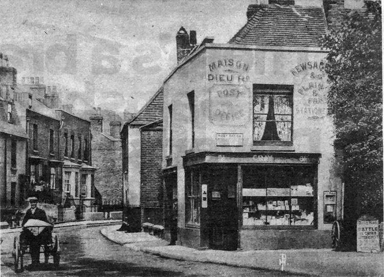
A view of Maison Dieu Road, near Peter Street, at the turn of the century, showing the old post office and newsagent’s shop of Mr R. Gray. This sub-post office and The Grapes public house close by were set back and re-built when the road was widened in the early part of this century. A Daily Mail placard outside the shop announced the shelling of the Taku Forts in the Boxer Rebellion, in China. Today Maison Dieu Road is considered to extend to Bridge Street, but until the Hitler war the area beyond The drapes was known as Charlton Green. There were over 30 homes there. Alma Place was on the river side and, opposite, were Palmerstone Terrace, the Sportsman Inn, Cooks Cottages and Castle Cottages. War damage and the needs of industry were responsible for their removal.
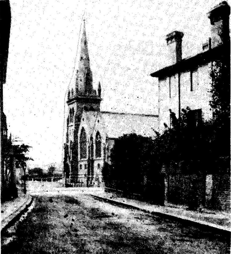
Below is a century-old view of the New St James’ Church as seen from the middle of Eastbrook Place, with open fields beyond.
|
|||||
|
If anyone should have any a better picture than any on this page, or think I should add one they have, please email me at the following address:-
|
|||||
| LAST PAGE |
|
MENU PAGE |
|
NEXT PAGE | |